Edmonton's North Saskatchewan River Valley cuts a 40-meter-deep swath through the city, exposing steep slopes carved into glacial till and Upper Cretaceous clay shale. Every spring, freeze-thaw cycles and rapid snowmelt trigger a fresh round of slope movements along the banks from Terwillegar Park to Capilano. The 2023 River Valley Planning Modernization project highlighted just how many properties sit within 50 meters of a valley crest, and with the city's population pushing past 1.1 million, infill development keeps pushing closer to these edges. A slope stability analysis here is not a paperwork checkbox: it is a geotechnical interrogation of pore pressures, relic shear surfaces, and the long-term creep behavior of the Bearpaw Formation. For sites with deep colluvium we often pair this with in-situ permeability testing to understand groundwater recharge paths into the slope face.
In Edmonton's Bearpaw shale, peak friction angles of 24 degrees can drop to 9 degrees residual after just 50 millimeters of shear displacement. That gap is where failures start.
Scope of work in Edmonton
Typical technical challenges in Edmonton
The Bearpaw Formation underlies most of Edmonton's river valley and behaves like a heavily overconsolidated clay shale with a nasty habit: it strain-softens. A cut that stands perfectly through August can begin creeping by October as matric suction dissipates and pore pressures redistribute. The 1999 Riverdale landslide and the more recent movement at Keillor Point both trace back to this mechanism: progressive failure along pre-sheared, low-angle bedding planes where residual friction angles drop below 10 degrees. Add the city's 1,200-meter elevation and the freeze-thaw penetration reaching 2.4 meters depth in an average winter, and you get a soil mass that sees 60 to 80 freeze-thaw cycles per year in the upper few meters. Each cycle opens microfractures, accelerates infiltration, and slowly ratchets the factor of safety downward. For slopes steeper than 18 degrees in weathered Bearpaw, we recommend inclinometer monitoring through at least two full seasonal cycles before certifying long-term stability.
Our services
Our slope stability work in Edmonton covers the full lifecycle from preliminary desktop review to post-construction monitoring. Every analysis runs through both limit equilibrium and finite element models so we can cross-check failure mechanisms and capture stress redistribution that simplified methods miss.
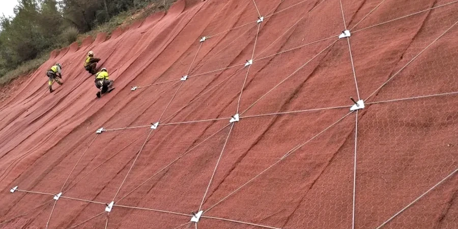
River Valley Slope Assessment
Stability modeling for natural and engineered slopes adjacent to the North Saskatchewan River and its tributary ravines. Includes stereonet kinematic analysis for structurally controlled failures in clay shale, transient seepage modeling for spring melt conditions, and FoS sensitivity to toe erosion and undercutting.
Construction-Phase Cut and Fill Stability
Temporary and permanent slope design for excavation benches, approach ramps, and fill embankments. We model staged construction sequences, evaluate short-term undrained conditions in glacial till, and specify depressurization measures — horizontal drains, drainage blankets, or deep wells — to maintain FoS above code minimums during the critical construction window.
Questions and answers
What factor of safety does the NBCC require for permanent slopes in Edmonton?
NBCC 2020 does not prescribe a single FoS value for slopes; it defers to geotechnical engineering standards. For permanent slopes in Edmonton, we target a minimum global factor of safety of 1.5 under static long-term drained conditions, and 1.1 for the seismic design case using a horizontal acceleration coefficient (kh) between 0.05 and 0.08 depending on site class. Temporary construction slopes may be designed to 1.3 provided monitoring is in place.
How does the Bearpaw Formation affect slope stability in Edmonton's river valley?
The Bearpaw Formation is a Cretaceous clay shale that exhibits strong strain-softening behavior: peak friction angles around 22 to 26 degrees can decay to residual values as low as 9 to 12 degrees after relatively small shear displacements. Pre-sheared bedding planes and bentonite seams are common, and these relic surfaces often govern stability. Any analysis that uses only peak strength parameters will overestimate the factor of safety, sometimes dangerously so.
Do I need a slope stability analysis for a single-family home near the river valley?
If the crest of the slope lies within a horizontal distance equal to three times the slope height from your building footprint, the City of Edmonton typically requires a geotechnical stability assessment as part of the development permit process. Even outside that zone, if site drainage discharges toward the slope or if there is evidence of historical movement such as tilted trees, tension cracks, or hummocky ground, a stability review is strongly recommended before any excavation or foundation work begins.
What is the typical cost range for a slope stability analysis in Edmonton?
How do freeze-thaw cycles influence slope stability in Edmonton?
Edmonton averages 60 to 80 freeze-thaw cycles annually in the upper 2.4 meters of soil. Each cycle creates microfractures that increase hydraulic conductivity over time, allowing spring meltwater to penetrate deeper and faster into the slope. This raises pore pressures at the till-shale interface just when snowmelt saturates the ground, and the combination is a primary trigger for shallow translational slides and mudflows observed each April and May along the river valley trails.